Josephine County, OR

Wildfire Smoke & Air Quality Alerts

RVEM
/ Categories: News
Wildfire Smoke & Air Quality Alerts 3505

Smoke levels can quickly rise and fall depending on weather factors, such as wind direction and how much smoke the wildfire produces. Therefore, people must be observant of the air quality during wildfire season.

Wildfire smoke is a complex mixture of air pollutants harmful to human health. Exposure to air pollutants in wildfire smoke can irritate the lungs, cause inflammation, alter immune function, exacerbate chronic heart and lung disease, and increase susceptibility to respiratory infections.

The particulate matter (also called “PM”) in wildfire smoke poses the biggest risk to the public’s health. Particles larger than 10 micrometers usually irritate only the eyes, nose, and throat. Fine particles 2.5 micrometers or smaller (PM2.5) can be inhaled into the deepest part of the lungs and even enter the bloodstream.

PM 2.5 levels have reached hazardous in Jackson County over the last 24 hours.

Populations known to be vulnerable to wildfire smoke exposures include:

  • Children less than 18 years;
  • Adults age 65 years or older;
  • Pregnant women;
  • People with chronic health conditions such as heart or lung disease, including asthma and diabetes;
  • Outdoor workers;
  • People of low socioeconomic status, including those who are experience homelessness and with limited access to medical care.

During a wildfire smoke event, Jackson County Public Health Officials advise people to take the following precautions:

  • Be aware of smoke concentrations in your area and avoid the places with the highest concentrations.
  • Avoid strenuous outdoor activity in smoky conditions.
  • Stay indoors with doors and windows closed. This reduces exposure to particulate matter in the air.
  • Use air conditioning to keep your home cool if it becomes too warm.
  • Other sources of particles within the home should be reduced or eliminated: smoking, using gas, wood‐burning stoves or furnaces, aerosol sprays, frying or broiling meat, burning candles or incense, and vacuuming.
  • High-efficiency particulate air (HEPA) filters and Electro-static precipitator (ESP) filters can help provide protection. The HEPA filters trap or remove harmful particles in the air.
  • If a HEPA or ESP filtering options are unavailable, you might consider a DIY option by attaching a furnace filter on a box fan. People may qualify for a free air conditioner or air filter through the Oregon Health Authority’s Air Condition and Air Filter Deployment Program.
  • Create a clean room(s) in the home to keep levels of smoke and other particles as low as possible during a wildfire smoke event.
  • When riding in a car, keep the windows and vents closed; turn the air conditioning on to recirculate.
  • Drink lots of water - staying hydrated can keep your airways moist, which will help reduce symptoms of respiratory irritation such as scratchy throat, running nose, and coughing.
  • People exposed to smoky conditions and who suffer from asthma or other respiratory problems should follow their breathing management plans or contact their healthcare providers.

If you must be outdoors when air quality is poor, wearing a special mask called a “particulate respirator” can also help protect your lungs from wildfire smoke. You will want to choose a mask called a “particulate respirator” that has the word “NIOSH” and either “N95” or “P100” printed on it. Masks that are not NIOSH-certified may not offer protection from small particulate matter, even if properly worn.

Many people will find it challenging to use particulate respirators. It is important to make sure the respirator fits properly, and that air does not leak around the sides. It is impossible to get a good seal on individuals with facial hair. If it does not fit properly, the respirator will not provide good protection and may offer the wearer a false sense of protection. Review the United States Environmental Protection Agency’s directions on how to properly wear a particulate respirator.

Particulate respirators can make breathing more difficult and increase breathing and heart rate. They can also contribute to heat stress. Because of this, particulate respirators used by those with heart and respiratory diseases should be done under a doctor’s supervision. Even healthy adults may find that the increased effort required for breathing makes it uncomfortable to wear a respirator for more than short periods. Check DEQ’s Air Quality Index (AQI) to see real-time air monitoring data from monitors placed around Oregon https://oraqi.deq.state.or.us/home/map. DEQ also has a mobile app for the AQI, search for OregonAir in your app store. Keep in mind that monitoring locations are limited, pollution levels may be higher in some areas, and wildfire smoke levels can rise and fall rapidly. Use the Oregon Smoke Information Blog, oregonsmoke.org, for updated air quality advisories, wildfire smoke forecasts, and other information.

Here are the six levels of the air quality index and what each level means for your health:
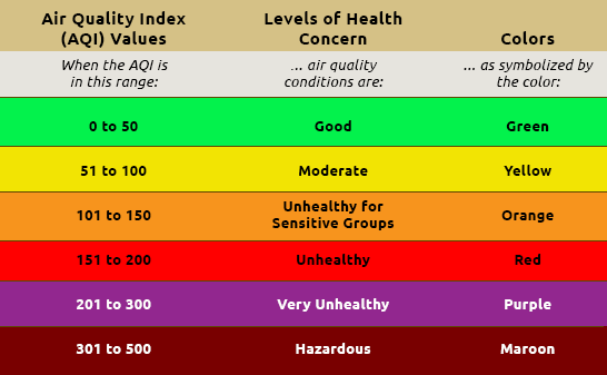
Air Quality Index Graph

Resources:

Print


Josephine County
Emergency Management
500 NW 6th Street
Grants Pass, OR 97526
em@josephinecounty.gov
541-474-5300

Follow us on Facebook

Josephine County, Oregon Facebook
icon
Josephine County Emergency Management
3/17/2025
1 0
icon
Josephine County Emergency Management
3/16/2025
21 1
The weekend's excessive rainfall in Southern Oregon has created widespread road-related impacts on county-maintained roads. Nearly all areas of the county road system are being impacted. Known problem areas as of 1:30PM Sunday - Lower River Road @ Hunt Lane is closed due to high water. Gene Brown Road, O'Brien, closed due to high water Pleasant Valley Road, between Merlin Road and Tavis Road, closed due to high water Upper River Road @ Ft Vannoy School, high water 7000-8000 block of North Applegate Road, near Noble Dairy, significant debris across road, proceed with caution. This is NOT an all-inclusive list, as conditions continue to change. Drivers are reminded to limit travel to essential activities and allow themselves extra time to get to their destination. Each year, more deaths occur due to flooding than from any other thunderstorm related hazard. The Centers for Disease Control and Prevention report that over half of all flood-related drownings occur when a vehicle is driven into hazardous flood water. The next highest percentage of flood-related deaths is due to walking into or near flood waters. People underestimate the force and power of water. Many of the deaths occur in cars swept downstream. Many of these drownings are preventable. Never drive around the barriers blocking a flooded road. The road may have collapsed under that water. A mere 6 inches of fast-moving flood water can knock over an adult. It takes just 12 inches of rushing water to carry away most cars and just 2 feet of rushing water can carry away SUVs and trucks. It is NEVER safe to drive or walk into flood waters. Residents can get information on sandbag suppliers at www.rvem.org/News/sandbags-faq" target="_blank">https://www.rvem.org/News/sandbags-faq For other safety tips www.rvem.org Turn Around Don’t Drown, National Weather Service: https://www.weather.gov/safety/flood-turn-around-dont-drown
icon
Josephine County Emergency Management
3/16/2025
22 1
The weekend's excessive rainfall in Southern Oregon has created widespread road-related impacts on county-maintained roads. Nearly all areas of the county road system are being impacted. Known problem areas as of 1:30PM Sunday - Lower River Road @ Hunt Lane is closed due to high water. Gene Brown Road, O'Brien, closed due to high water Pleasant Valley Road, between Merlin Road and Tavis Road, closed due to high water Upper River Road @ Ft Vannoy School, high water 7000-8000 block of North Applegate Road, near Noble Dairy, significant debris across road, proceed with caution. This is NOT an all-inclusive list, as conditions continue to change. Drivers are reminded to limit travel to essential activities and allow themselves extra time to get to their destination. Each year, more deaths occur due to flooding than from any other thunderstorm related hazard. The Centers for Disease Control and Prevention report that over half of all flood-related drownings occur when a vehicle is driven into hazardous flood water. The next highest percentage of flood-related deaths is due to walking into or near flood waters. People underestimate the force and power of water. Many of the deaths occur in cars swept downstream. Many of these drownings are preventable. Never drive around the barriers blocking a flooded road. The road may have collapsed under that water. A mere 6 inches of fast-moving flood water can knock over an adult. It takes just 12 inches of rushing water to carry away most cars and just 2 feet of rushing water can carry away SUVs and trucks. It is NEVER safe to drive or walk into flood waters. Residents can get information on sandbag suppliers at www.rvem.org/News/sandbags-faq" target="_blank">https://www.rvem.org/News/sandbags-faq Other information about floods and safety tips www.rvem.org Turn Around Don’t Drown, National Weather Service: https://www.weather.gov/safety/flood-turn-around-dont-drown
icon
Josephine County Emergency Management
3/16/2025
4 0
UPDATE: 2/25/25 10:00am: Wayne has been located safely. * Date of Report: 02/24/2025 Case: 25-4214 Name: Wayne David Morris Age: 76 Sex: Male Race: White Height: 5'5" Weight: 180 Hair: Gray Eyes: Blue Information: Wayne was reported missing late Monday night. He was last seen on Vine Street around 3:00pm on 2/24/25. He was driving a gray 2020 Chevrolet Silverado with OR license plate 593MMB. The OnStar app shows the vehicle's last known location to be in the Hog Creek area around 4:30pm later that day. SAR has been activated. Please contact the Josephine County Sheriff's Office with any information. Phone: 541-474-5123
icon
Josephine County Emergency Management
2/25/2025
15 0
Update 02/03/2025 12:30pm: ODOT: SW Oregon: I-5 NB, MP 66: UPDATE - Crews have cleared stalled trucks in the northbound lanes of Interstate 5, 8 miles north of Grants Pass. Expect continued delays throughout the area due to winter conditions. Avoid travel until conditions improve. Visibility is limited; turn on headlights. Check road conditions at https://tripcheck.com/" target="_blank">https://tripcheck.com/ . More Info ODOT: SW Oregon: I-5 NB, MP 66: Expect delays in the northbound lanes of Interstate 5, 8 miles north of Grants Pass while crews work to clear stalled trucks blocking the road. Visibility is limited. Postpone travel until conditions improve. Do not detour on local or forest roads. Expect delays throughout the area due to winter conditions. Check road conditions at https://tripcheck.com/" target="_blank">https://tripcheck.com/ . More Info
icon
Josephine County Emergency Management
2/3/2025
13 0
Load more posts Loading